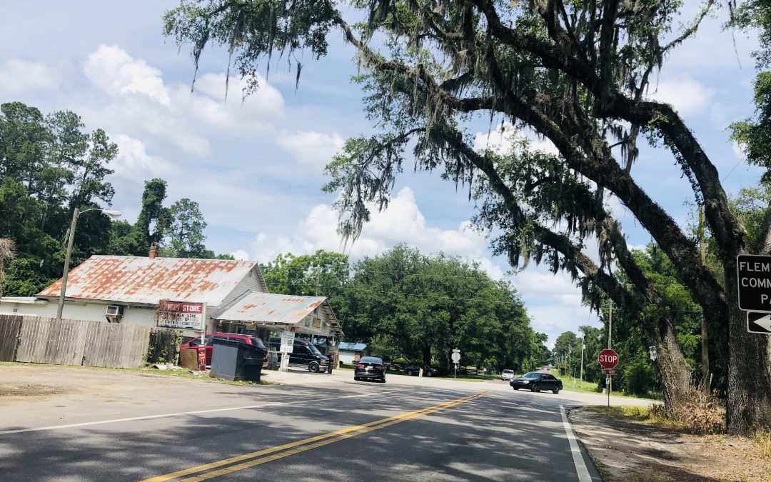
The Flemington Store, at the corner of W Hwy 318 and N Hwy 329, in the heart of the Farmland Preservation Area. There is now a Dollar General across the street.
Family Dollar Store to be built in the FPA
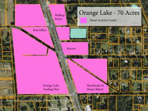
Soon there will be a new Family Dollar store in Orange Lake at the intersection of W Hwy 318 and US Hwy 441. While this intersection is one of the gateways to the Farmland Preservation Area (FPA), it is located in one of the 10 Rural Activity Centers (RAC) that are designated for this exact type of business. The property already has the correct land use/zoning and is being built by BP 5440 Micanopy, LLC and the Contineo Group.
Marion County’s comprehensive plan allows for limited commercial and residential development in designated Rural Activity Centers (RAC) (Policy 2.1.21) The new Family Dollar store is a perfect example of what the RACs were designed for – to allow small mixed use commercial islands within the rural areas to help residents and businesses meet some of their daily needs and to reduce trips to the urban areas.
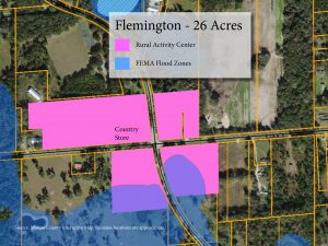
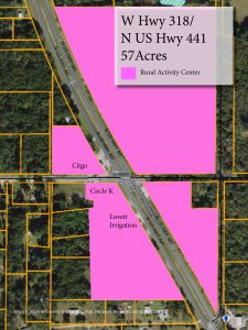
At the intersection of CR 318 and 441 in Orange Lake, all four corners have the RAC land use and it encompasses about 57 acres. In 2021, the rural community of Flemington grew with a new Dollar General store, which is located in the Flemington RAC. All four corners of the intersection of W Hwy 318 and N Hwy 329 are included in the RAC. The new Dollar General is located across the street from the old Flemington Store, which has been a part of the community for over 50 years. The new store is a little bit of a stark contrast with the old store and its white clapboard siding and rusty metal roof.
Marion County’s comprehensive plan does not include design guidelines for the 10 RACs to help protect the rural character of the FPA, but there are design guidelines for the area around the Florida Horse Park as part of the CR 475A Visual Enhancement Gateway Development Overlay. The design guidelines cover signs and include additional buffering and landscaping as well as the optional addition of a three-board fence.
While the design elements are not required for the new Family Dollar, if the company included them, it would be a symbolic statement to the community that Family Dollar supports protecting the character and culture that horses and horse farms create in the FPA.
Groceries, Gas, Baling Twine…
Marion County’s rural area is vast. Just the Farmland Preservation Area is 193,000 acres. The RAC future land use designation allows for mixed use nodes of residential and commercial uses, including agricultural-related commercial uses. These commercial islands within the rural areas are beneficial because they help residents and businesses meet some of their daily needs and also reduce trips to the urban areas.
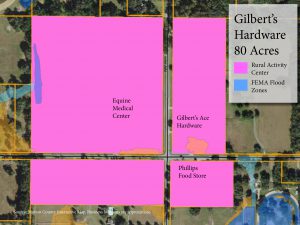
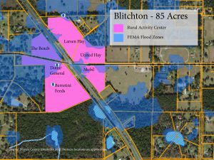
Some of the additional commercial uses allowed in RACs include hardware stores like Gilbert’s Hardware at the intersection of Hwy 225A and CR 326, gas stations, post offices, and grocery stores. In the Blitchton area, on US 27 near H.I.T.S. and many of the sport horse farms, there are 3 feed stores and 2 restaurants – Berrettini Feed Specialists, Larsen Hay and United Hay for horses and The Beach and Yum Yum Kitchen for riders and trainers – important services conveniently-located for hard working equestrians.
In addition to the commercial development, the RAC allows for higher density residential development. In the RAC, up to two dwelling units per acre are permitted. Even in the FPA, the residential density can be up to two dwelling units per acre inside the RAC. Outside of the RAC, to help protect the rural character of the FPA, the zoning is one dwelling unit per 10 acres.
The development standards for RACs – the distance from the intersection, the allowed uses, the set backs and the building heights – are the same no matter where they are located, even if the RAC is located inside the Farmland Preservation Area (FPA).
For commercial uses, the floor area ratio is 35% – that means that the buildings can only occupy 35% of each parcel.
For properties that are not located in the RAC and are zoned Agriculture (A-1), landowners are permitted to set up a roadside stand to sell hay or vegetables that are grown on the same property.

The RAC Pack
There are 10 RACs dispersed throughout the FPA that average about 54 acres each. When you combine the acreage, that is about 540 acres. However, the size of any RAC can be expanded to a maximum of 96 acres, if it meets the criteria:
- No greater than ¼ mile or 1,320 feet from the center of the intersection;
- 85% developed; and
- at least 5 miles from another RAC.
These 10 RACs all have a Future Land Use designation of RAC, but for some parcels, the Zoning is not RAC.
Marion County has two RAC classifications: a land use designation and a zoning classification. The Future Land Use (FLU) designation is a generalized classification and sets the development densities. The Zoning specifies which exact uses are allowed versus prohibited on that parcel. This is important to distinguish because a parcel could be designated with a FLU RAC, but have a Zoning of A-1 for agricultural use instead of commercial use. In order for the FLU RAC parcel to be used for commercial purposes, the Zoning would have to be changed. There are some “grandfathered in” exceptions for historically-zoned commercial properties with RAC Land Use that are treated as if they also have RAC Zoning.
HFF Text Amendment: A Chance to Change
If a parcel in a RAC does not have the correct zoning, then the zoning has to be changed in order for potential applicants to build a commercial or residential building. Through this zoning change process, there is an opportunity to submit public comments to the Planning & Zoning Commission and to the Board of County Commissioners because the Horse Farms Forever® Amendment enhances the definition of Rural Character and further requires that all applications for Zoning Requests and Special Use Permits “be consistent with and preserve, protect and support and enhance the rural, equestrian, and farmland character of the Farmland Preservation Area.”
As part of Horse Farms Forever’s role in protecting the character and culture of the Farmland Preservation Area, we are actively monitoring all applications that are submitted for consideration. Watch our posts and blogs for updates and opportunities to make comment as RAC’s come up for zoning changes. Please join us as a member and support our efforts to uphold Marion County’s rural lifestyle and brand as the Horse Capital of the World®.
Click on each of the RAC’s below to see a detailed map provided courtesy of Marion County’s Interactive Map:
The maps were created using Marion County’s online map. The maps show the the size and location of parcels designated with a FLU of RAC in each of the 10 areas within the FPA. The online map viewer is not intended to be a legal document but rather for reference. We thank the County for providing this helpful resource.
1. N Hwy 329/W Hwy 318 - Flemington
Click on the image to see full size.
2. NW 193rd Street/N US Hwy 441 - Orange Lake
Click on the image to see full size.
3. W Hwy 318/N US Hwy 441
Click on the image to see full size.
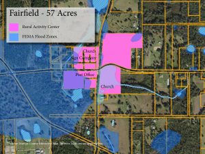
4. W Hwy 316/NW Hwy 225 - Fairfield
Click on the image to see full size.
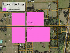
5. W Hwy 329/NW Gainesville Road - Lowell
Click on the image to see full size.
6. CR 326/NW Hwy 225A - Gilbert's Hardware
Click on the image to see full size.
7. W Hwy 326/US 27 Blitchton
Click on the image to see full size.
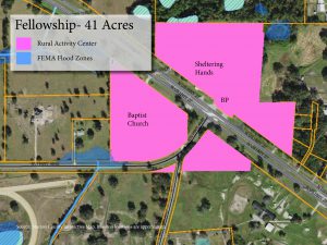
8. NW Hwy 464B/US 27 - Fellowship
Click on the image to see full size.
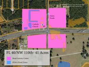
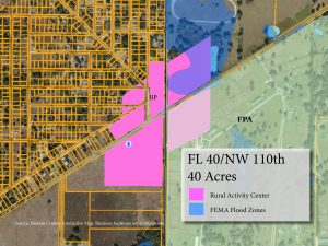
9. FL 40/NW 110th Avenue
Click on the image to see full size.
10. FL 40/SW 140th Avenue
Click on the image to see full size.

Commercial uses on World Equestrian Center (“WEC”) designated lands in the Rural Area
For land located in the Rural Area that is also part of the World Equestrian Center (WEC) Planned Unit Development, there is a different land use classification called World Equestrian Center (WEC). (Policy 2.1.28.) The WEC designation allows for commercial uses, recreational uses, residential uses, recreational vehicle parks (“RVP”) and mixed uses. Any commercial uses on World Equestrian Center (“WEC”) designated lands in the Rural Area (i.e., outside the Urban Growth Boundary) are limited to equestrian-related uses associated with the World Equestrian Center.
Examples of equestrian-related uses include polo fields, equestrian arenas, equestrian instruction facilities, veterinary clinics, farriers (non-mobile), stables and barns, and feed stores and tack shops. Any and all accessory uses to equestrian-related uses are ancillary and incidental to such equestrian related use and are located on the same lot or parcel as the principal equestrian-related use. The maximum density for residential uses within the WEC Rural Area is (1) dwelling unit per ten (10) gross acres.

What About Zoning?
The Zoning regulations are found in the Land Development Code, which is a separate document with specific guidelines to implement the Goals, Objectives, and Policies of the Comprehensive Plan.
Zoning regulates development through land use classifications and specifies the areas in which residential, industrial, recreational or commercial activities may take place. The Land Development Code was adopted through a series of ordinances by the County Commission, which means that the regulations cannot be changed or waived, except by a further vote of the County Commission.
Always Watching

We work hard to keep you informed, and to represent our members' interests in preserving our horse farms, farmland and the unique character and culture of Marion County's 193,000 acre Farmland Preservation Area.
Join the herd. Every voice matters.
RAC in the FPA are important to maintaining a rural feel.
However, in order to keep that rural feel with new construction extra effort needs to be made regarding design elements of the building. Additionally, with the Dollar General Parcel my concern would be the provision for adequate Semi parking for delivery of goods.
My experience with the Dollar General on US 441 south of McIntosh is less than favorable regarding these two elements of the Permitting Process with Marion County.
I did not oppose this Dollar General because I understood the financial need for the family who sold the site to the Developer of the Dollar General. Also, I felt that the location, although not ideal, utilized convenient access via US 441.
However, due diligence regarding storm-water runoff from the structure and parking were lacking. Soon after the construction completed, the selling property owner’s adjoining property to the west was flooded. This was unfortunate but avoidable if Marion County had required more land for proper drainage.
Parking for deliver of goods is not adequate at the US 441 site.
My expectation for the new Dollar General would be to improve upon these elements and perhaps even go a step further with a more Rural facade to compliment the existing commercial. Travelling around Florida Rural areas can be pleasant when one encounters a Dollar General facade in keeping with the historic facades of the area.
The Rudiyani Family is a nearby resident with many years of experience with development. John Rudiyani has a keen eye for the land and its abundance of natural resources. His vision and implementation at the Canyon Zip Line is a most recent example. Perhaps he would be willing to lend that same attention to detail for the upcoming Dollar General right in his own back-yard.
I would personally be grateful.
Thank you for staying on top of what is going on in the FPA, and keeping us informed.
Please continue to do so and add me to your email list.
Joanna Valerioti