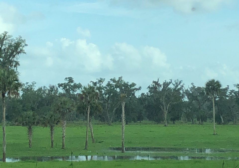
Above is a photo taken yesterday of the proposed site for the Double Gate ATV Park in Flemington. Does this look like a good place to put “dry ATV trails?”
On Soil and Topography Alone, the Double Gate Location Fails
Neighbors to the proposed Double Gate ATV Park continue to write the County Commissioners with clear opposition and good evidence to support their contention that the Flemington location is not suitable for this use. Here is a letter from Rick Robbins, a nearby resident and former Soil and Water Conservation District employee.
Dear Commissioners (especially Commissioner Stone),
This email is in regards to the proposed Double Gate ATV park near Flemington, Florida. As a landowner in District 5 of Marion County, I am concerned about the possibility of introducing a land use that is not compatible with the current Zoning in the designated “Farmland Preservation Area”. The intent of previous commissioners was to protect this area from incompatible land uses and to foster the stewardship of agriculture in NW Marion County. I believe we should respect and honor the work of our past commissioners.
Over 91 percent of the soils within the footprint are designated as Farmlands of Local Importance.
Hydric Soils/Wetlands: Hydric Soils are one of the components of wetlands, hydrology and vegetation are the others. Over 50 percent of the soils within the footprint are designated as hydric soils and could be wetlands if the other 2 criteria are met. Please note that the USFWS wetland delineations often do not include wetlands rating in agricultural areas (pastures, etc.)
Soil Interpretations:
- Erosion Hazard: Offroad/Offtrail – Many of the soils (over 40%) in the area have either a Moderate or Severe rating for Erosion (Off-Road). This means that there will be soil loss from the site and possible off-site impacts resulting in site degradation and unintended off-site consequences.
- Soil Rutting Hazard: 100% of the soils within the footprint have a moderate limitation for Soil Rutting Hazard. This causes soil degradation and can channel water to affect and accelerate offsite impacts.
- Suitability for Roads: Over 50% of the footprint have soils that are Poorly Suited for Roads with Natural Surfaces due to wetness.
- Building Site Development: 100% of the soils are very limited to Buildings (with or without basements) due to wetness, shrink-swell potential, and a few soils are subject to ponding. This should be considered when evaluating the site for an RV Park.
- Camp Areas: 100% of the soils are very limited to camp sites (due to wetness), which should be considered when evaluating the site for an RV Park.
- Off-Road Motorcycle Trails: 100% of the soils are either Very Limited (78%) or Somewhat Limited (22%) for motorcycle trails due to wetness.
- Sanitary Facilities (Septic Tank Absorption Fields): 100% of the soils are Very Limited to either Sanitary Facilities and Septic Tank Absorption Fields. This is also a consideration when considering an RV Park at the location.
Soil Properties:
- Seasonal High Water Table: All soils (100%) within the project footprint are poorly drained with a seasonal high water table within 12 inches of the soil surface.
- Clay Content: All soils have over 35% clay within 20 inches of the soil surface. Clay minerals are smectitic which means they are highly expansive (shrinking and swelling). This can affect construction, such as, concrete slabs, foundations, etc.
- Permeability: Moderately slow to very slow. This means that water transmission through the soil profile is highly restricted. This will affect water movement on the soil surface since water cannot enter the soil profile. In addition, the use of ATV’s will compacted the soil and increase overland water movement to offsite locations.
- Slope: Most of the soils have slope above 2 percent and up to 8 percent. Slope along with restricted permeability means that water will move offsite, and even more so…. during tropical events.
- Offsite Impacts: All of the above soil properties can result in onsite degradation that moves to offsite locations. The slope and restricted permeability means that pollutants, sediment, and surface water will most likely move offsite, unless retaining structures are built to mitigate the effects..
Conclusion: There has to be a better location for an ATV/RV park than the proposed location. Soil characteristics, Farmland Preservation classification, and the rural environment around the proposed site should make the rejection of this proposal…a no-brainer. I am OPPOSED to the ATV Park at it’s proposed location.
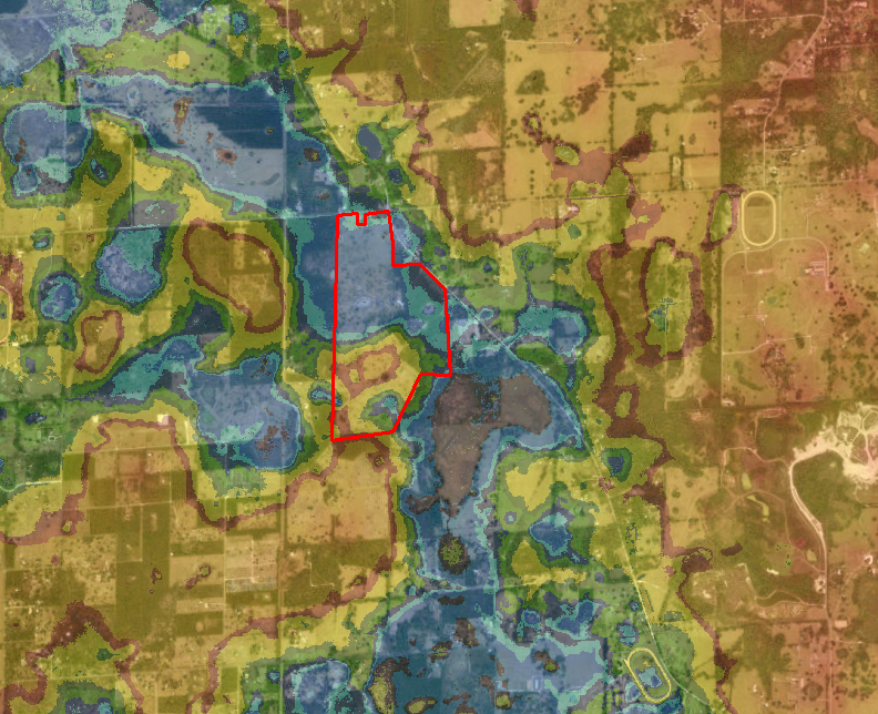
Blue Means Low and Wet
Let’s look at the proposed ATV Park site from a regional perspective. Most of the surrounding land has a higher elevation. All of the rainfall (and groundwater recharge) is going to accumulate in this drainage basin, and if the rainfall totals are high enough….they will bridge the levee and move significant water offsite and to the southeast. This map illustrates how water moves across the land. The red polygon is the proposed site. Red and yellow hues are higher elevations, green- mid-level elevation, and blue hues are lower elevations. If this graphic doesn’t illustrate what off-site impacts will occur (and where), I don’t know what will. The proposed site is in an extremely large drainage basin with significant areas of local recharge.
Soils of Local Importance
Lest you think this is a boggy and useless piece of property, we’d like to point out that the proposed ATV Park sits in the middle of one of the largest areas of “#8 soil” in the County. This soil is considered ideal for agriculture, particularly for pasturing livestock. It is designated as “Locally Important Farmland” by the USDA. The Farmland Preservation Area was created to protect these soils. Our supply of them is finite and valuable for farming.
No Brainer For You?
Last week, we wrote about how the decibel limit for ATV noise can not be met on this site. Today, Rick Robbins showed that the soils can not support an ATV Drag Strip and Racing Trails. Read the comments on our blogs – neighbor after neighbor is asking the County to oppose and deny this flawed plan in the wrong location. In an upcoming blog, we’ll show that there are many existing good locations for ATV trail riding and racing. It is not necessary to invade the Farmland Preservation Area.
What’s your story? The Commissioners need to hear it.
I worked in this area for 8 years passing this corner property. It was mostly under water in years past.
Really good soil analysis from an expert. I hope that it hits the targeted minds.
Rick Robbins thank you for a well written report by an expert.
Mr. Robbins,
Your information is excellent, and your photo shows exactly what I also sent to the commissioners. The property to be developed is located 300 ft. from my property and I fear increased flooding to my home and property. Thank you sir for putting into words what will happen if this area is developed. It shows why the Farmland Protection Area is so important to North Marion county.
Horse farms forever,
My husband and I are so appreciative of the work you are doing to preserve this area!
We live within walking distance of this property and drive through this intersection for everything we do,from going to work,to doing errands,going to dinner,or appointments as well as going to our church which is located on 318. We have lived in Marion. county for 20 years and decided to move here 4 years ago because it is a tranquil and peaceful area,and it is so much closer for us to attend our services at the monastery down the road. We chose this area specifically for those reasons,as It sure all the residents here have chosen this area because of it’s farmland potent Io all and the peacefulness here. There another areas in Marion county that are zoned for the type of activity that the people of Doublegate propose to build in this preserved section of the county.People love to come here to get away from hustle and bustle of city & suburban life.
If this were to pass ,it would set a dangerous precedent for this area,by opening the doors to more and more businesses ,forever changing the character and serene environment that the people wish to preserve. Let’s keep at least this part of Marion County true to it’s nature and maintain it’s designated as “Farmland Preservation”. If they wanted to create an nice agricultural /botanical park possibly have horse riding trails, that at least would be more fitting for this area. I would still be concerned with the zoning change for commercial business, however. Keep the Farmland beauful and peaceful!
Thanks for the encouragement, Kimberly. We hope you will take a moment to send a note to the County Commissioners saying the same thing, and if you can, show up at the meeting. Your elected officials need to see the faces of the community and hear their voices – every single one counts!
I am totally opposed to this change and have written to the Commissioners in opposition. Along with the specific information detailing the application and amendment I also included a personal message…
“I am a local Realtor. and as I’m sure you’ve heard from many of us, we are in a particularly unique position to understand the nuances of what zoning changes can do. I understand completely that sometimes zoning changes are necessary and a part of the expected growth and change that happens over time. I also understand and value what the creation of the Farmland Preservation Area has accomplished. We have a place in the WORLD that is unlike anywhere else. If we, as a community, do not fight tooth and nail to protect that, we would be totally derelict in our duty as stewards of this incredible place. Not only do I conduct business within the Farmland Preservation Area, I also live within it and am a short distance from the proposed site change. I am a tax paying/voting citizen of Marion county and our little corner of it is one of the things I value most. Please do not allow an inappropriate use of our land.