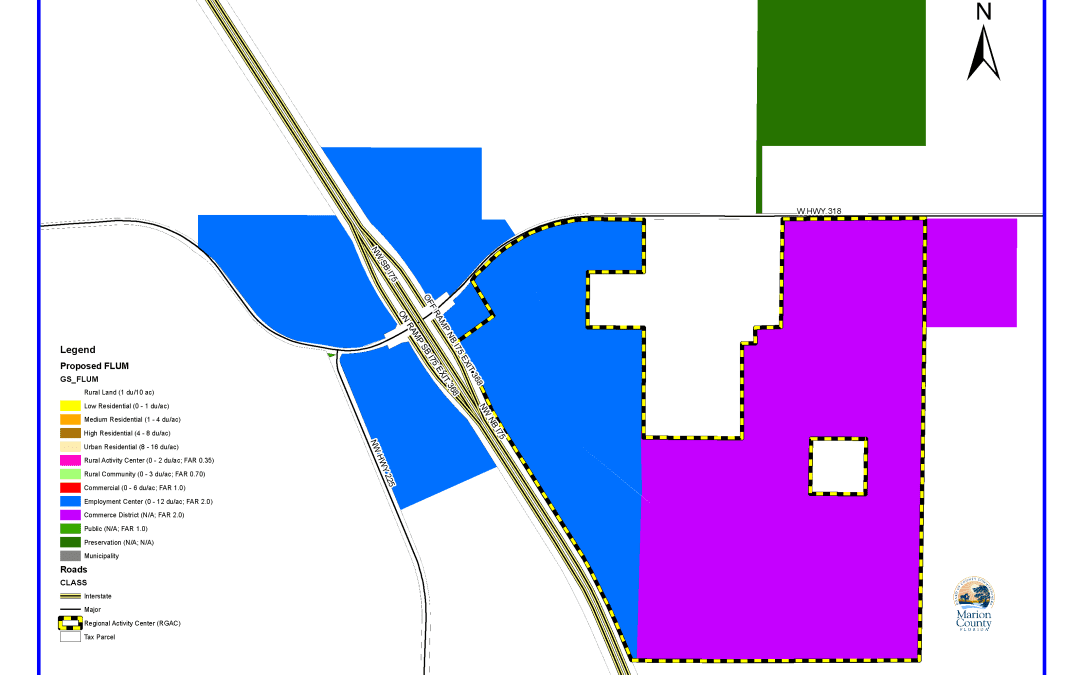
On the map, the blue areas have a Future Land Use designation of Employment Center (includes residential and commercial/industrial) and the purple is Commerce District (limited to industrial and commercial uses.) The 453-acre Sunny Oaks Regional Activity Center (RGAC) border is designated by the yellow and black hash marks.
What We’re Watching in Irvine
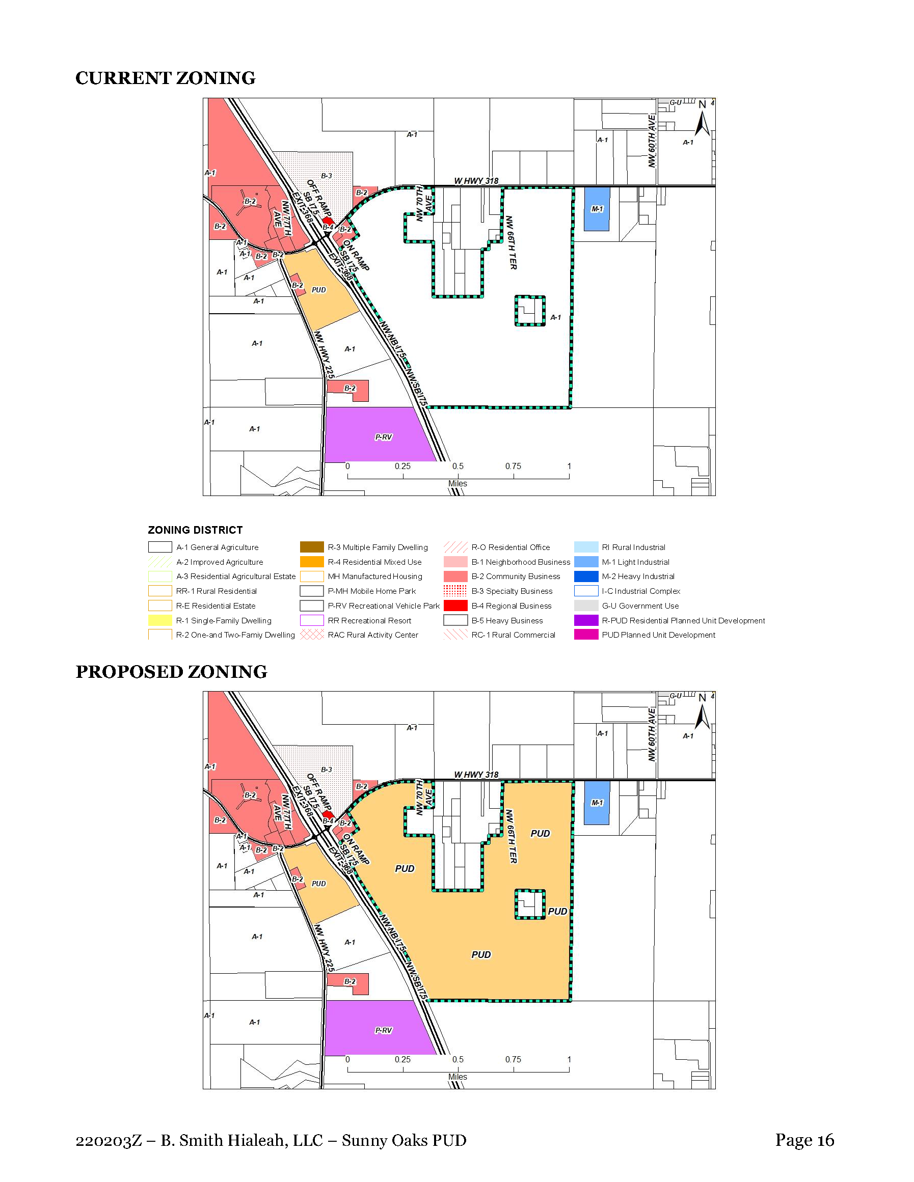
The Irvine/Sunny Oaks Regional Activity Center is on the March 1, 2022, Marion County Commission agenda to request a change in zoning from Agriculture (A-1) to Planned Unit Development (PUD).
The PUD zoning classification is intended to provide a process for the evaluation of unique individually planned residential, commercial, industrial, and mixed-use developments, which may not otherwise be permitted in the standard zoning classifications established by this Division.
The proposed 453-acre Sunny Oaks PUD is a catalyst project that will forever change the rural and scenic character of the intersection at CR 318 and I-75 in Irvine. The community and local residents are justly concerned about the long-term impacts of the proposed 4 million square feet of commercial and warehouse space on traffic and their quality of life.
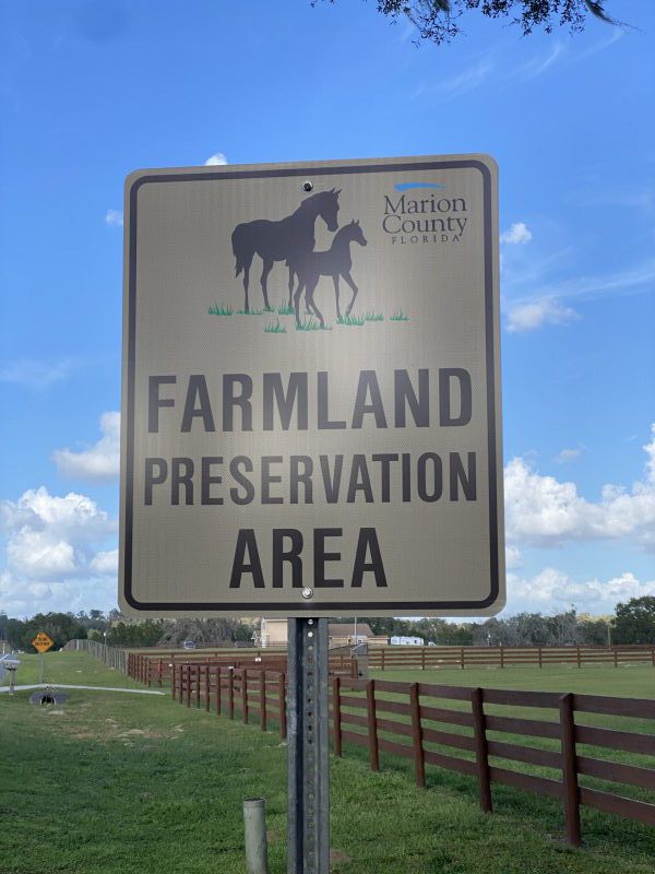
Because this project is located within the Farmland Preservation Area (FPA), Horse Farms Forever has recently spent hundreds of hours researching the proposed Sunny Oaks Zoning Request. We consulted with our land use attorney, key stakeholders and land use planners to better understand the complex legal issues and the scope of the previous development agreements and determine if there was a role for HFF. This is a summary of what we found.
Zoning Change
The Irvine/Sunny Oaks RGAC is adjacent to the Highway 318 interchange on I-75. This interchange includes a Future Land Use Element designation in the Comprehensive Plan that includes an Employment Center, a Commerce District and a Regional Activity Center. While this parcel is within the Farmland Preservation Area boundaries, these Future Land Use designations overlay and override the Farmland Preservation Area regulations and restrictions.
As a result of the above designations and classifications, the owner of this parcel has a legal right to rezone this parcel from agriculture to an implementing zoning district for the specific Future Land Use designation. This legal right was established in 2012 when the RGAC was created and revised in 2014.
While the requested zoning change is to Planned Unit Development, there are other options that would satisfy the legal obligation of the County to rezone the property to an implementing zoning district. Nonetheless, they all allow significant retail, commercial and industrial development.
The Marion County Growth Services Staff has done an excellent job in their report detailing the very complicated history and facts surrounding this parcel and the zoning change request. In addition, the Growth Services report contains recommendations of significant conditions. Most importantly, while the developer has provided a Conceptual Plan for the development, a Master Plan for the Planned Unit Development has not been provided, which is a required critical element in establishing the scope, scale and other details of the project.
Traffic Concerns
Traffic capacity and safety of the intersection at I-75 and CR 318 was also addressed in the staff report. The interchange has not been updated from the original 1964 design and CR 318 is a winding two-lane road with limited visibility on the east side of the interstate. The Growth Service’s staff report states: “Prior to obtaining final PUD Master Plan approval, completion and review of the project’s formal traffic study will be required with the resolution of any level of service and/or design deficiencies identified being addressed consistent with the applicable Land Development Code (LDC) provisions.”
If the Commissioners approve the zoning request to PUD, then a PUD Master Plan of the parcel is required. The Growth Services staff report states: “The final PUD Master Plan, or equivalent shall require review and approval by the Marion County Board of County Commissioners.”
Learn More About Sunny Oaks
- Horse Farms Forever’s Position Statement on the Sunny Oaks RGAC
- Growth Services Staff Report about the Sunny Oaks RGAC
- Site Plan for Sunny Oaks PUD
- Marion County’s Comprehensive Plan (Search for Irvine Regional Activity Center)
A User-Friendly Guide to Zoning Jargon
Future Land Use (FLU) Designation: a classification of a property that explains what types of development can be built on that property in the future.
Future Land Use Map: The future land use map is a community’s visual guide to future planning. The future land use map should bring together most if not all of the elements of the comprehensive plan such as natural resources, economic development, housing and transportation.
Zoning: A method of urban planning in which a municipality or other tier of government divides land into areas called zones, each of which has a set of regulations for new development that differs from other zones.
What is the Difference Between Future Land Use (FLU) and Zoning?
Future Land Use FLU designations indicate the intended use and development density for a particular area, while zoning districts specifically define allowable uses and contain the design and development guidelines for those intended uses.
Planned Unit Development (PUD): A type of flexible zoning device that redefines the land uses allowed within a stated land area. PUDs consist of site plans that promote the creation of open spaces, mixed-use housing and land uses, environmental preservation and sustainability, and development flexibility.
Overlay Zone: A zoning district which is applied over one or more previously established zoning districts, establishing additional or stricter standards and criteria for covered properties in addition to those of the underlying zoning district.
Regional Activity Center (RGAC) in Marion County’s Comprehensive Plan: The purpose of a RGAC is: “To allow for compact, high intensity, high density multi-use development which may include a mix of the following uses: retail, office, housing, cultural, recreational and entertainment facilities, hospitality facilities (hotels and motels), and industrial uses that serve a regional area.”
Always Watching

We work hard to keep you informed, and to represent our members' interests in preserving our horse farms, farmland and the unique character and culture of Marion County's 193,000 acre Farmland Preservation Area.
Join the herd. Every voice matters.

What About Zoning?
The Zoning regulations are found in the Land Development Code, which is a separate document with specific guidelines to implement the Goals, Objectives, and Policies of the Comprehensive Plan.
Zoning regulates development through land use classifications and specifies the areas in which residential, industrial, recreational or commercial activities may take place. The Land Development Code was adopted through a series of ordinances by the County Commission, which means that the regulations cannot be changed or waived, except by a further vote of the County Commission.
My husband is currently down with Covid Pneumonia and I’ve been advised this will be a long term recovery, maybe taking months. He is unable to be left alone, at the current time. Can anyone be appointed as our proxy to make our voices heard. We are against this proposal!