fbpx
HFF Talks Turnpike with FDOT

HFF Talks Turnpike with FDOT

We Sat Down with FDOT and Learned Some Things about the Northern Turnpike Extension That You May Not Know

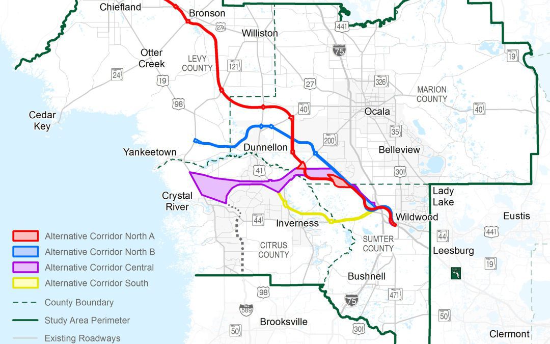
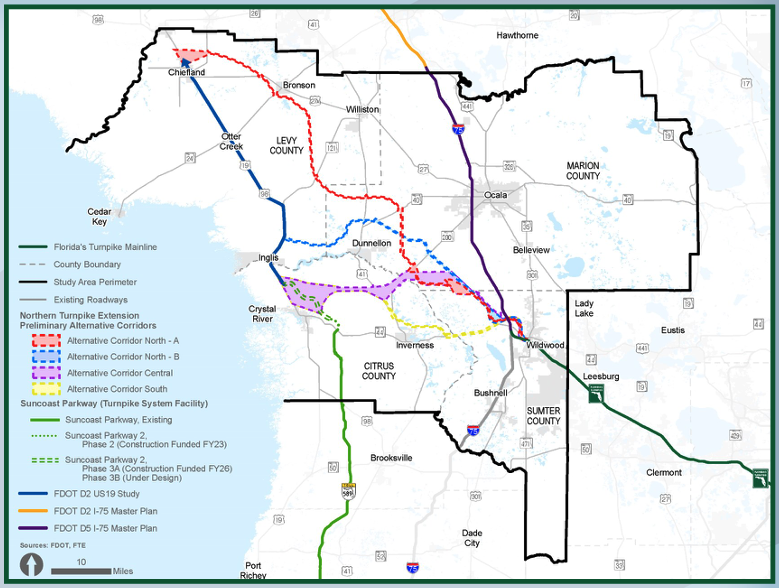
In October 2021, Florida’s Turnpike Enterprise (FTE), part of the Florida Department of Transportation (FDOT), began an Alternative Corridor Evaluation (ACE) study to evaluate the extension of Florida’s Turnpike from its northerly terminus in Wildwood to a logical and appropriate terminus as determined by FDOT.  The Northern Turnpike Extension (NTE) study area includes Citrus, Levy, Marion, and Sumter counties.

Horse Farms Forever® has taken a neutral position on the ACE Study because the four proposed corridors were not located inside the Farmland Preservation Area.

HFF’s policy statement on transportation reads: Any new road projects within the Farmland Preservation Area should use existing rights-of-way. This position aligns with Marion County’s Comprehensive Plan Policy 3.3.1 Elements of Rural Character which states: “Transportation: New transportation corridors intended to be used specifically for the construction of expressways or limited access roadways shall avoid the Farmland Preservation Area.”

In our role as a watchdog of government actions, Horse Farms Forever® staff recently met with members of the NTE project team from FTE to learn more about the process of developing corridors and the parameters used to evaluate corridor alternatives, and ultimately select a route for the proposed NTE.

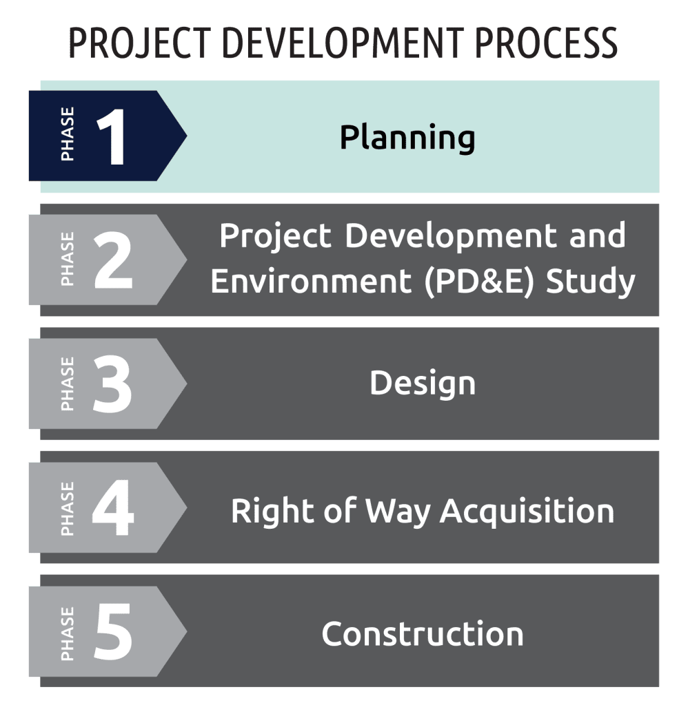
Phase 1 Is All About Choosing A Corridor

In the next 20 years, Florida’s population is projected to increase by five million people to 26 million residents.(1) With this expected population growth, the transportation systems must also grow to provide a safe and reliable transportation network. To accommodate this growth, FTE is conducting a study to evaluate an extension of Florida’s Turnpike. The ACE process is used to identify, evaluate, and eliminate alternative corridors on qualifying projects. The main goal of the ACE study is to narrow the potential four corridor alternatives down to one corridor.
Phase 2 Will Look At Several Alignments – And Also No Build

The recommended corridor from the ACE study is the basis for Phase 2 of the project, the Project Development and Environment (PD&E) study phase. In this phase, the recommended alternative corridor goes through further detailed evaluation to refine a range of alternatives within the selected corridor. The PD&E study will also evaluate a No-Build option as well as potential Transportation Systems Management and Operations (TSM&O) improvements such as ramp signals or work zone traffic management.

“It’s a long process and we are very early in the planning phase. There are five steps from planning to construction and finally operation,” said William Burke, FTE Project Manager (HDR). “We are evaluating all of the corridors against the goals of the project, but also how they impact the environment, traffic, and cost.”

Jennifer Stults, FDOT Planning and Environmental Management Administrator, emphasized that this phase is focused on mapping by using Geographic Information Systems (GIS) data and characterized it as an exercise in avoidance to help protect environmentally sensitive areas, natural resources and residential areas.

“At this phase, the corridors are broad to allow us to evaluate the area, but we will narrow the focus and refine the corridors based on information that is processed. This will allow us to accommodate those areas that we want to avoid,” said Stults. She also emphasized that the project team is sensitive to local land use decisions and conservation areas. “We want to be a good partner,” said Stults. “We work closely with our local partners to identify some of the things in process that we would not be aware of yet. This is why our ongoing robust community engagement work is so important. We absolutely want to hear from our stakeholders.”

For example, not only are existing conservation areas avoided, but also the areas that have been identified for conservation as part of a local or state program, or those areas that are part of the optimum boundary of the conservation area. In addition to public conservation lands such as state parks, the team is also mindful of privately-owned land with a conservation easement that has been delineated in the GIS mapping data.

 “There are a lot of different types of conservation land with different types of habitat, and if there is land with a conservation easement here and one without a conservation there, we are going to route around the land with the easement whenever possible,” said Burke. “There could be some exceptions, but generally speaking we would avoid those areas as much as possible.”

Conservation Is Written Into The Statute

The ACE study will identify preliminary environmental impacts and any potential impacts to existing conservation lands will be further evaluated and mitigated in the PD&E study to the greatest extent possible. 

There are two important sections in the enabling Statute to mitigate environmental impacts:

(7) The department shall consider innovative concepts to combine right-of-way acquisition with the acquisition of lands or easements to facilitate environmental mitigation or ecosystem, wildlife habitat, or water quality protection or restoration.

(8)(b) To the greatest extent practicable, roadway alignments, project alignment, and interchange locations shall be designed so that project rights-of-way are not located within conservation lands acquired under the Florida Preservation 2000 Act established in s. 259.101 and the Florida Forever Act established in s. 259.105.

NTE Scope Is Narrower than M-CORES

The NTE and Multi-use Corridors of Regional Economic Significance (M-CORES) program are different projects. The goals of the NTE are to enhance regional connectivity, accommodate increased travel demand, address regional congestion and safety, and improve emergency response. The M-CORES program conversely had a broader statewide goal of implementing regional corridors that were intended to accommodate multiple modes of transportation and multiple types of infrastructure. The M-CORES program was planned to address various issues beyond those typically accommodated in FDOT projects such as broadband, water, and sewer connectivity; energy distribution; trade and logistics; mobility as a service; and availability of a trained workforce skilled in traditional and emerging technologies, among others.

During the 2021 legislative session, Florida Statute 338.2278, repealed M-CORES.  The same legislation authorized study of the NTE. 

Interchange Features Can Be Controlled By Local Governments

The project team will work with local governments to determine the location of proposed interchanges and to determine the features of the interchange, such as a gateway feature or region-specific landscape features. Local governments can also include restrictions in the comprehensive plan to determine development around the interchange. This is one way to reduce urban sprawl.

“In Citrus County, there is an interchange management plan,” said Stults. “Also, along the Turnpike, with limited access, there are areas where minimum development has occurred for decades. That is where the local planning agencies are able to choose what they would like to see happen in their community.”

Project Schedule Is Driven By Public Interest

FTE initiated the planning phase of the Northern Turnpike Extension project in October 2021. The project is currently in early stages of development with the Efficient Transportation Decision Making screening and the ACE underway. Based on the high level of engagement and interest, FDOT is increasing opportunities to engage with local governments, stakeholders, and residents within the study area. The additional engagement efforts and increased public interest are underway and will continue to influence the project schedule. The project website remains an up-to-date and dependable resource for information and opportunities to provide feedback. Public engagement will continue to shape how the Northern Turnpike Extension supports regional and statewide needs as it moves through all phases of the project development process.


Source: Northern Turnpike Extension – Florida’s Turnpike (floridasturnpike.com)

NTE End Point Will Be Decided

 One of the main goals of the ACE study is to determine the project limits. Stults also emphasized that public participation is important and will help influence the route of the corridor.

 “The Northern Turnpike Extension will end at a point that is to be determined only after further study is completed and feedback from stakeholders is reviewed. We are still in that gathering process,” said Stults.

Because SB 100 (2021) gave the FDOT the authority to determine the end point for the NTE, it does not have to connect with the Suncoast Parkway. This gave the project team more flexibility when developing the four corridor alternatives.

The two northern corridor alternatives end at different locations along US 19 (98), while the central and the southern corridors end at US 19 (98) or the future location of the Suncoast Parkway. The longest corridor (Alternative Corridor North A) stretches nearly 75 miles across three counties to end at Chiefland. The three other corridors take a more westerly direction and are much shorter.

The legislation requires the FDOT to take into consideration the previous task force reports. These reports may help determine the route.

 (6) Any existing applicable requirements relating to turnpike projects apply to projects undertaken by the Turnpike Enterprise pursuant to this section. The Turnpike Enterprise shall take into consideration the guidance and recommendations of any previous studies or reports relevant to the projects authorized by this section and ss. 339.67 and 339.68, including, but not limited to, the task force reports prepared pursuant to chapter 2019-43, Laws of Florida, and with respect to any extension of the Florida Turnpike from its northerly terminus in Wildwood.

***

Horse Farms Forever® thanks the Florida’s Turnpike Enterprise team for taking the time to discuss the process of selecting corridors and the parameters used to select a route for the proposed Northern Turnpike Extension project. 


Public Input Requested

In addition to holding public meetings, the Department engages the public on all its projects and welcomes your feedback.

The project team also strongly encourages residents to submit comments using the online comment form.

 “Just keep an open mind and give us as many detailed comments as you want to submit,” said Stults. “Folks are entitled to their opinion, but the more specific the suggestions are, the more it helps the team fine-tune the route.”

For other project information, please contact:

William Burke, PLA

Project Manager
Florida’s Turnpike Enterprise (HDR)

407-264-3142 | william.burke@dot.state.fl.us

Northern Turnpike Extension Webpage: www.floridasturnpike.com/NTE


Suncoast Parkway 2 Under Construction

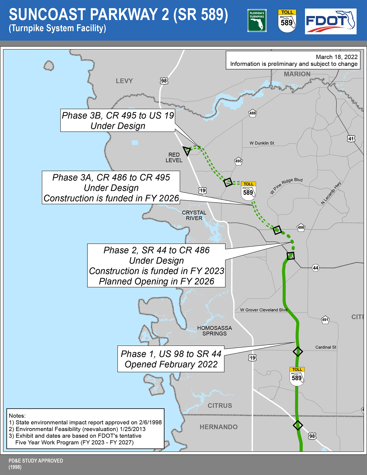
The Suncoast Parkway 2, or the Suncoast extension, is shown on the study area map for the Northern Turnpike Extension project, but it is a separate road improvement project that is located entirely in Citrus County. Phase 1 of the Suncoast Parkway extension was recently opened to traffic and ends at SR 44. Phases 2 and 3 are in the Design Phase and sections of the road are funded for construction. These sections combine for 13 miles, starting at SR 44 and connecting to US 19.

Here’s a link to a detailed map, information, and schedule. 
It is the vision and mission of Horse Farms Forever to inspire conservation of horse farms through education, awareness and idea exchange so as to preserve natural pasture land focusing on horses and their habitats, to protect soil and water on which they depend, and minimize land use conflicts
in Marion County, Florida.

We are watchful of government and others to preserve and protect horse farms and farmland for future generations - especially in the Farmland Preservation Area. We are neither anti-growth nor anti-development; we encourage urban growth to remain inside the Urban Growth Boundary.

Horse Farms Forever® is a Florida not-for-profit corporation registered with the Florida Department of Agriculture and Consumer Services as a charitable organization and approved as a tax-exempt 501(c)(3) corporation by the Internal Revenue Service. Horse Farms Forever® does not have a political mission. Our status as a 501(c)(3) charitable organization does not allow us to participate or intervene in political activities. The organization will neither advocate on behalf of political candidates nor advocate for the passage of legislation.

 

The Master Plan For I-75

The Master Plan For I-75

From The Turnpike to CR 234 – The Latest on Fifty Miles of Improvements

There is no doubt that I-75 is near capacity. To accommodate the projected population growth and increased truck traffic, the road’s capacity will have to be expanded.

Over the next 20 years, Marion County’s population will grow by about 150,000 new residents to reach nearly half a million people. In addition, the industrial warehouse space will increase to a total of 17M square feet. About half of the existing 11M square feet of industrial warehouse space is used by five distribution centers and an additional six million square feet of industrial warehouse space will be completed over the next 12 to 18 months.

This exponential growth will stretch the capacity of I-75 to its limits.

I-75’s capacity issues have been on the Florida Department of Transportation’s (FDOT) radar since 2016, with the formation of the I-75 Relief Task Force. The top recommendation from the Task Force was to improve the capacity of I-75. The second recommendation was to improve existing roads such as 41, 441 and 301.

In 2018, the Coastal Connector was proposed by FDOT, but since that was rejected, I-75 became the focus again in 2019. (The Northern Turnpike Extension was proposed by the Florida Turnpike Enterprise (FTE), which is part of FDOT in 2021).

Scope Of The Project

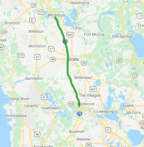
In 2021, FDOT decided to take a step back and refresh the Master Plan for I-75. The project starts in Sumter County at the northern terminus of Florida’s Turnpike in Wildwood and goes north for 47.8 miles to County Road (CR) 234 just north of Marion County. 


The Master Plan will only evaluate upgrading I-75 within the existing corridor. The project is divided into two sections for the purposes of the study.

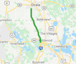
Section 1 starts at the Florida Turnpike to 22.5 miles north to State Road (SR) 200.

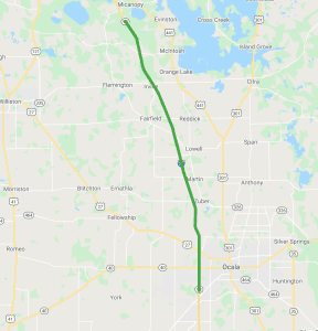
Section 2 starts at SR 200 in Marion County to 25.3 miles north to County Road (CR) 234 in Alachua County.

Timeline

The work on the I-75 Master Plan began in June, 2021. The draft  Master Plan report will be available sometime in June, 2022. A public meeting will be held in summer, 2022 for public comment and the final Master Plan report is due in November, 2022. The next phase is PD&E followed by Design and Construction. The FDOT Project Manager for the I-75 Master Plan is Mary McGehee. FDOT is also working with two consulting engineering firms, Volkert and HDR, Inc. to conduct the I-75 Master Plan study.

“The Master Plan will look at the short-term and the long-term solutions,” said Steven Schnell, an engineer with HDR, Inc. “The long-term solution looks out to 2050 and what needs to be done. This is such a long corridor and it will be implemented in phases to determine what is the best strategy and plan going forward.”

Some of the short-term solutions include enhanced ramps and better signals at some of the interchanges. The intersections at CR 236, SR 40 and SR 200 will also be improved.

“The biggest issues are at CR 326,” said McGehee. “That’s where the trucks are getting on and off of I-75. The two truck service centers at this intersection also adds to the congestion as the trucks intermingle with the cars.”

The long-term improvements will be included in the Master Plan study and potentially include adding two additional lanes and new interchanges. The goal is to improve the traffic flow and safety, and to further reduce the amount of time to clear traffic incidents. The variation in the traffic due to the holidays, weekends, inclement weather, incidents and the truck traffic will also be addressed in the report.

Ocala’s Strategic Location

FDOT has the Herculean task of planning for the future transportation needs for Marion County. The good news is that the majority of the road improvements are made within existing corridors.

Marion County is growing quickly and the roads must also grow. Ocala’s strategic location between several major cities and readily available land along I-75 is one of the reasons several large distribution centers have chosen Ocala for their relocation or expansion needs. For tourists and commuters, I-75 is also the most direct route to the Turnpike and to south Florida’s popular west coast.

42 Projects

There are currently 42 FDOT projects in Marion County that are at various stages. You can submit comments or ask a question about each project on the FDOT District Five website.

We’ll Be Watching

The improvement of I-75 is one of the most significant transportation issues facing the county. I-75 also runs through the Farmland Preservation Area, so we will be monitoring the I-75 Master Plan and attending the public meeting this summer. We thank the FDOT team for updating us about the road improvement project because it will have a tremendous impact on the quality of life in Marion County. FDOT has decades of institutional experience and their goal is to make I-75 better and safer for all travelers.


Already In The Design Phase

New I-75 Interchange at NW 49th Street/NW 35th Street

The Florida Department of Transportation (FDOT) is building the new interchange at NW 49th Street/NW 35th Street. According to the FDOT website, the Project Development and Environment (PD&E) Study was completed in March 2021 and the project is currently in the design phase. The FDOT Design Project Manager is Megan Owens and the Design Firm is Metric Engineering.

Construction is anticipated to begin in August of 2024. The cost of the project is approximately $41 million for construction. The estimated time frame for completion is 1 to 3 years.

Read our blog on this project

Link to the PD&E study and a comment form to send comments to FDOT.

Busy Shires

What About Zoning?

The Zoning regulations are found in the Land Development Code, which is a separate document with specific guidelines to implement the Goals, Objectives, and Policies of the Comprehensive Plan.

Zoning regulates development through land use classifications and specifies the areas in which residential, industrial, recreational or commercial activities may take place. The Land Development Code was adopted through a series of ordinances by the County Commission, which means that the regulations cannot be changed or waived, except by a further vote of the County Commission.

Always Watching

We work hard to keep you informed, and to represent our members' interests in preserving our horse farms, farmland and the unique character and culture of Marion County's 193,000 acre Farmland Preservation Area.

Join the herd. Every voice matters.

UPDATE: Five Major Road Widening and Intersection Improvements

UPDATE: Five Major Road Widening and Intersection Improvements

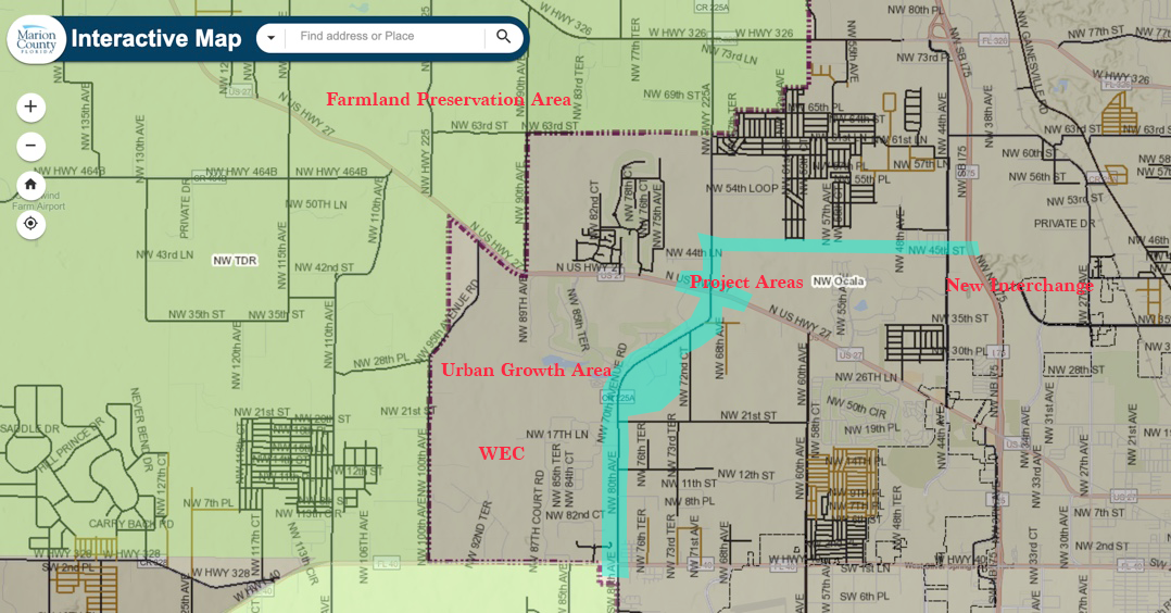
Using Marion County’s Interactive Map, we’ve roughed in the project areas (turquoise blue). As you can see, they are within the Urban Growth Boundary and outside of the Farmland Preservation Area.

by Busy Shires
April 27, 2021

Did you notice all the extra traffic and snow birds this winter in Ocala? To accommodate for the increase in traffic – from cars, to horse trailers and big trucks – there are five major road projects in Marion County. These road projects will make the roads safer for people and horses around the World Equestrian Center and they will help the big trucks gain better access to I-75. The good news is that all five projects are located outside of the Farmland Preservation Area.

With the opening of the World Equestrian Center (WEC), Marion County is becoming the epicenter for horse owners seeking the warmth of a Florida winter to train and show their horses. During this winter’s show season, over 2,000 horses showed at WEC! That’s in addition to the nearly 80,000 horses that already call Marion County home.

Marion County’s distribution industry is also booming. Over the next five years, an additional 5 million square feet of industrial and warehouse space will be built to accommodate several new distribution centers. This square footage is in addition to the existing Fed Ex, Chewy’s, Amazon, AutoZone, and Dollar Tree distribution centers. The central location of Ocala with easy access to Jacksonville and Tampa via I-75 has made the area an ideal distribution hub.

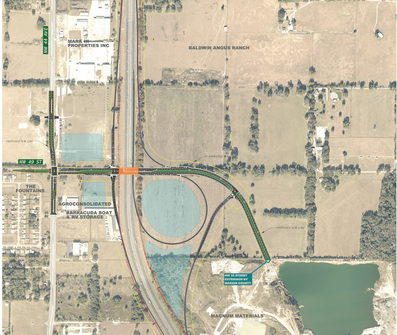
One of the largest road projects is a new interchange on the east side of I-75 at NW 49th St/NW 35th St. This new interchange will travel over I-75 to connect into the existing road at NW 49th St./NW 44th Ave. on the west side. A new intersection will also be built at NW 49th St./NW 44th Ave. From this new intersection, a new two-lane road will be built to connect to CR 225A north of the intersection at US 27.

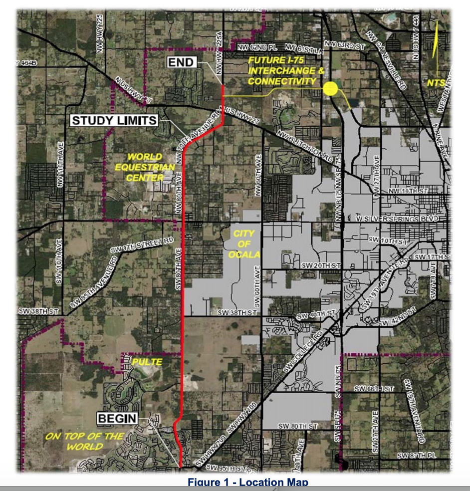
In addition, NW 70th Ave./NW 80th Ave. will be four-laned from SW 80th St. to 600 feet North of US 27. The intersections at each end of NW 70th Ave./NW 80th Ave. at US Hwy 27 and Hwy 40 will be improved with turn lanes. Also, 600 feet on both the north side of US 27 and the south side of Hwy. 40 will also be four-laned.

CR 225A will remain a two-lane road from the 600-foot intersection improvement at US 27 to the proposed road that connects CR 225A to NW 44th Ave. There are no additional plans to four-lane CR 225A further north of the new road at NW 44th Ave.

The Drop Down Links Below Provide More Detail On Each of the Five Projects:

1. NW 70th Ave./CR 225 A and US 27

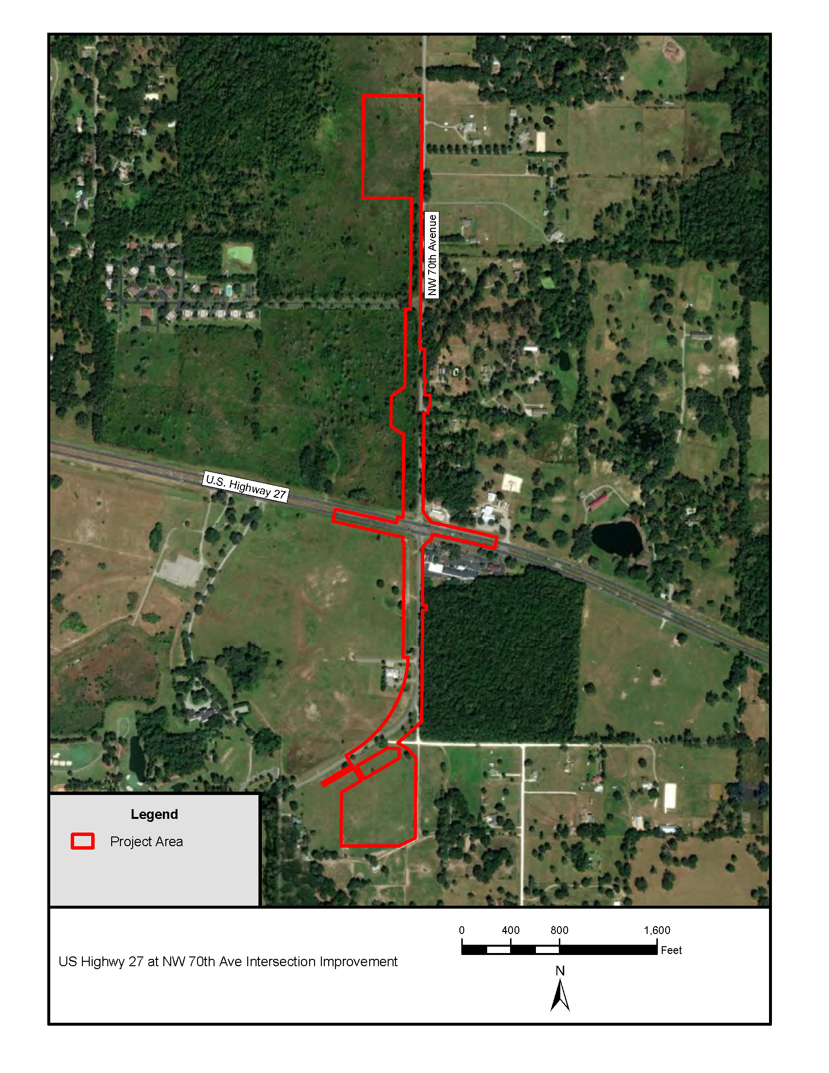
The improvement of the intersection at NW 70th Ave./CR 225 A and US 27 is the first project. The long-term goal is to improve both of the intersections at the north and south ends of NW 70th Ave./NW 80th Ave. The north section is located at US Hwy. 27 and NW 70th Ave./CR 225A and the south section is located at Hwy. 40 and NW 80th Ave.

The intersection improvements extend approximately 600 feet on both sides of US 27. The map shows the location of the improvements, the intersection “approaches” and the Drainage Retention Areas (DRAs) north and south of US 27.

This project is funded by Marion County for a cost of approximately $4.7 million. Guerra Development Corp. is the design engineer and Commercial Industrial Corporation is the contractor.

This project is about to schedule a pre-construction meeting. The recent pre-construction meeting was cancelled until further notice. At the pre-construction meeting, all the interested parties meet to discuss the start date. After this meeting, the County’s Procurement Department will issue a Notice to Proceed for construction.

Other than the 600 feet included in the intersection improvements, this road will not be four-laned further north. There are also no additional plans to four-lane CR 225A further north of the new road at NW 44th Ave. This section of CR 225A is not located in the Farmland Preservation Area.

2. NW 80th Ave. and Hwy. 40

This project will consist of improving the intersection and approaches at Hwy. 40 and NW 80th Ave. The design of this intersection improvement will be similar to the intersection improvements at NW 70th Ave./CR 225A and US 27, but they are not complete; thereby no plans are available for viewing.

3. Four-Lane of NW 70th Ave./NW 80th Ave.

NW 70th Ave./NW 80th Ave. will be four-laned from SW 80th St. to 600 feet North of US 27. This project is in the design/survey phase and is predicted to start in 2023 or 2024.

4. New I-75 Interchange at NW 49th St./NW 35th St.

The Florida Department of Transportation (FDOT) is building this new interchange. Steven Buck is the Project Manager at FDOT. This interchange will extend from the NW 35th St. extension that Marion County is constructing, which ends at the Amazon warehouse. The new street will go through the mining operation. This new FDOT interchange will go over I-75, via a bridge, from NW 35th St. on the east side and it will tie into the existing NW 49th St. on the west side of I-75.

This is a diverging diamond interchange configuration. Marion County has requested that the interchange include design features that will help the County further define it’s identity as the Horse Capital of the World® such as live oak “canopy” trees rather than palm trees for landscaping and three-board fencing rather than chain link fencing around the retention areas. These design features will help the interchange serve as a gateway into the area.

On the west side of I-75, a new intersection at NW 49th St. and NW 44th Ave. will be built. Traffic will have access to NW 44th Ave., which runs parallel to I-75 and connects to US 27 and Hwy. 326.

The project is in the design phase and it is fully funded for all phases (design, right of way and construction.) Construction is anticipated to begin in December of 2024. The cost of the project is approximately $40 million for construction.

5. Future Connection of CR 225A to NW 49th St./NW 44th Ave.

This road project is funded by Marion County. The connection of CR 225A to the new intersection at NW 49th St./NW 44th Ave. is under design. A preliminary engineering report presenting various options was developed by Guerra Development Corp. and accepted by the Marion County Board of County Commissioners during 2010.

Funding of eventual construction is planned to take place at two intervals:

  1. NW 49th St. (1.1 mi west of NW 44th Ave. to NW 44th Ave.), Phase 3A for FY 2020/21, length = 1.1 miles.
  2. NW 49th St. (CR 225A to 1.1 mi west of NW 44th Ave.), Phase 3B for FY 2022/23, length = 2.3 miles.

This video rendering from the FDOT illustrates how a diverging diamond intersection works.

Learn More

This is the most up to date information obtained from the Marion County Engineering Department and the Florida Department of Transportation. However, all schedules are subject to change, based upon funding. Marion County’s Transportation Improvement Program (TIP) is updated yearly.

Florida Department of Transportation – District 5 HQ (Deland) – 386-943-5171

Ocala/Marion TPO (Transportation & Planning Organization) – 352-438-2630

Marion County Office of the County Engineer  – 352-671-8686

Always Watching

We work hard to keep you informed, and to represent our members' interests in preserving our horse farms, farmland and the unique character and culture of Marion County's 193,000 acre Farmland Preservation Area.

Join the herd. Every voice matters.

Horse Farms Forever Neutral on Proposed Alternative Routes for the Northern Turnpike Extension

Horse Farms Forever Neutral on Proposed Alternative Routes for the Northern Turnpike Extension

Florida’s population is growing and with that growth, the state’s transportation systems will also need to grow. Therefore, it makes sense for the Florida Department of Transportation to conduct feasibility studies of potential routes for these future transportation needs, including the Northern Turnpike Extension.    

The Horse Farms Forever position on transportation is clear and consistent.

  • Any new road projects within the Farmland Preservation Area should use existing rights-of-way. This position aligns with Marion County’s Comprehensive Plan Policy 3.3.1 Elements of Rural Character which states: “Transportation: New transportation corridors intended to be used specifically for the construction of expressways or limited access roadways shall avoid the Farmland Preservation Area…”
  • HFF did not oppose the Coastal Connector Tollway. Instead, what we opposed were the routes through the heart of the most prime Marion County horse farms and especially the Farmland Preservation Area. Our goal was to help the leadership of the FDOT understand the impact of their proposed routes. Once provided with the facts, they had the good judgment to abandon those proposed routes. 

The proposed alternative routes for the Northern Turnpike Extension avoid the Farmland Preservation Area and prime Marion County horse farms. Thus, at this time, Horse Farms Forever takes a neutral position on the proposed alternatives to the northern extension of the turnpike.

In our watchdog role, HFF continues to closely monitor the situation to assure there are no detrimental impacts to the Farmland Preservation Area. In addition, we are interacting with the FDOT on a regular basis to better understand the project.

The mission of Horse Farms Forever is to inspire conservation of horse farms through education, awareness and idea exchange so as to preserve the character and culture that horses and the Farmland Preservation Area make unique to Marion County. We are watchful of government and others to preserve horse farms and farmland for future generations, especially in the Farmland Preservation Area. We are neither anti-growth nor anti-development, rather encouraging urban growth to remain inside the Urban Growth Boundary.

Horse Farms Forever is registered with the Florida Department of Agriculture and Consumer Services as a charitable organization and approved as a tax-exempt 501(c)(3) corporation by the Internal Revenue Service. Horse Farms Forever does not have a political mission. Our status as a 501(c)(3) charitable organization does not allow us to participate or intervene in political activities. The organization will neither advocate on behalf of political candidates nor advocate for the passage of legislation.
Date: December 7, 2021
Time: 5:30 – 7:30 PM
Place: College of Central Florida
Levy Campus, 15390 US-19
Chiefland, FL 32626

Date: December 9, 2021
Time: 5:30 – 7:30 PM
Place: College of Central Florida Citrus Campus
3800 S Lecanto Highway
Lecanto, FL 34461

Public Hearing Notice: I75 Interchange at NW 49th Street

Public Hearing Notice: I75 Interchange at NW 49th Street

A Chance to Comment on the I75 Interchange at NW49th Street

On Wednesday, November 18, 5:30 to 7:30 pm, a public hearing will take place. We will be there as FDOT shares the results of their study. The public is invited to comment on the “the location, conceptual design, and social, economic and environmental effects of the proposed improvements.” We intend to suggest some improvements that would make the interchange a fitting gateway for the Horse Capital of the World® and the Farmland Preservation Area. It is our intention always to work collaboratively and affect positive change where necessary to protect Marion County’s global brand. Instructions for participation in person and virtually are in the hearing notice below:

Dear Government Partner:

The Florida Department of Transportation (FDOT) invites you to a public hearing regarding the Interstate 75 (I-75) at NW 49th Street Interchange Project Development and Environment (PD&E) Study. The location of the proposed interchange is at NW 49th Street, approximately two miles north of the I-75 and U.S. 27 interchange in Marion County. The public hearing will be held on Wednesday, November 18, 2020, from 5:30 p.m. to 7:30 p.m.

The purpose of the PD&E Study is to evaluate proposed improvement alternatives for the I-75 at NW 49th Street Interchange. This hearing is being conducted to give interested persons an opportunity to express their views concerning the location, conceptual design, and social, economic and environmental effects of the proposed improvements. The preferred alternative consists of a new diverging diamond interchange with on and off ramps to NW 49th Street, similar to a traditional diamond interchange. However, along NW 49th Street, the two directions of traffic crossover, or diverge, to the opposite side at the on/off ramps.

The Department is offering two ways for the community to participate in the hearing. Interested persons may join the Virtual Public Hearing (VPH) from a computer, tablet or phone. Or, they may participate in person by going to the Southeastern Livestock Pavilion, 2232 NE Jacksonville Road, Ocala, Florida 34470. All participants, regardless of platform they choose, will participate in the same live hearing.

A VPH is a free live presentation or webinar over the internet. If you wish to participate in the VPH online from a computer, tablet or mobile device, registration is required in advance by going to: https://attendee.gotowebinar.com/register/8139573940021629453. Once registered, participants will receive a confirmation email containing information about joining the VPH online. At this time, Internet Explorer is not supported by GoToWebinar, and the link for the meeting will not work on this platform. Please use an alternate web browser to register and attend the meeting. For participants who are unable to attend the webinar, they can listen to the hearing by calling (562) 247-8422 and entering access code 505-938-223 when prompted. Please note, while the call-in number is listen-only, callers may submit comments directly to the project manager by using the contact information listed below.

For those who choose to participate in person, the Department requests advance registration to ensure all attendees are accommodated safely and according to social distancing guidelines. Attendees will be asked to follow all safety and sanitation guidelines as well as adhere to any local ordinances. To register for the in-person option, please contact FDOT Project Manager Amy L. Windom, P.E., by phone at (386) 943-5074 or via email at amy.windom@dot.state.fl.us. Attendees who are not feeling well should not attend the in-person meeting.

The VPH and in-person meeting location open at 5:30 p.m. on November 18. A formal narrated PowerPoint presentation will begin promptly at 5:45 p.m., followed by a formal public comment period. If joining online, please provide adequate log-in time to view the presentation in its entirety.

All meeting materials, including the presentation, will be available on the project website at www.cflroads.com/project/435209-1 by November 20, 2020.

The project documents (draft environmental and engineering reports) are available for public review at the following locations:

  1. Ocala Public Library, 2720 East Silver Springs Boulevard, Ocala, FL 34470 (Monday – Thursday, 10:00 a.m. – 8:00 p.m.; Friday and Saturday, 10:00 a.m. – 6:00 p.m.; Sunday, 1:00 p.m. – 5:00 p.m.)
  2. DeLand Library, 130 E. Howry Avenue, DeLand, FL 32724 (Monday – Thursday, 9:00 a.m. – 6:30 p.m.; Friday and Saturday, 9:00 a.m. – 5:00 p.m.)
  3. Online at www.cflroads.com/project/435209-1

Persons wishing to submit written statements, in place of or in addition to oral statements, may do so at the hearing or by sending them to Amy L. Windom, P.E., FDOT Project Manager, via email at amy.windom@dot.state.fl.us, or by U.S. Mail to 719 S. Woodland Boulevard, Mail Station 501, DeLand, FL 32720. While comments about the project are accepted at any time, please send your comments by December 1, 2020 to be included in the records for this public hearing.

Public participation is solicited without regard to race, color, national origin, age, sex, religion, disability, or family status. Persons wishing to express their concerns relative to FDOT compliance with Title VI may do so by contacting Jennifer Smith, FDOT District Five Title VI Coordinator at Jennifer.Smith2@dot.state.fl.us.

Persons who require accommodations under the Americans with Disabilities Act (ADA) or persons who require translation services (free of charge) should contact Amy L. Windom, P.E., FDOT Project Manager, at 386-943-5074 or amy.windom@dot.state.fl.us at least seven (7) days prior to the hearing.

The environmental review, consultation, and other actions required by applicable federal environmental laws for this project are being, or have been, carried out by the FDOT pursuant to 23 U.S.C. §327 and a Memorandum of Understanding dated December 14, 2016 and executed by the Federal Highway Administration and FDOT.

We encourage you to participate in the I-75 at NW 49th Street Interchange PD&E Study public hearing. If you have any questions or comments about the project, please contact Amy L. Windom, P.E., FDOT Project Manager, at 386- 943-5074 or amy.windom@dot.state.fl.us.

Always Watching

We work hard to keep you informed, and to represent our members' interests in preserving our horse farms, farmland and the unique character and culture of Marion County's 193,000 acre Farmland Preservation Area.

Join the herd. Every voice matters.