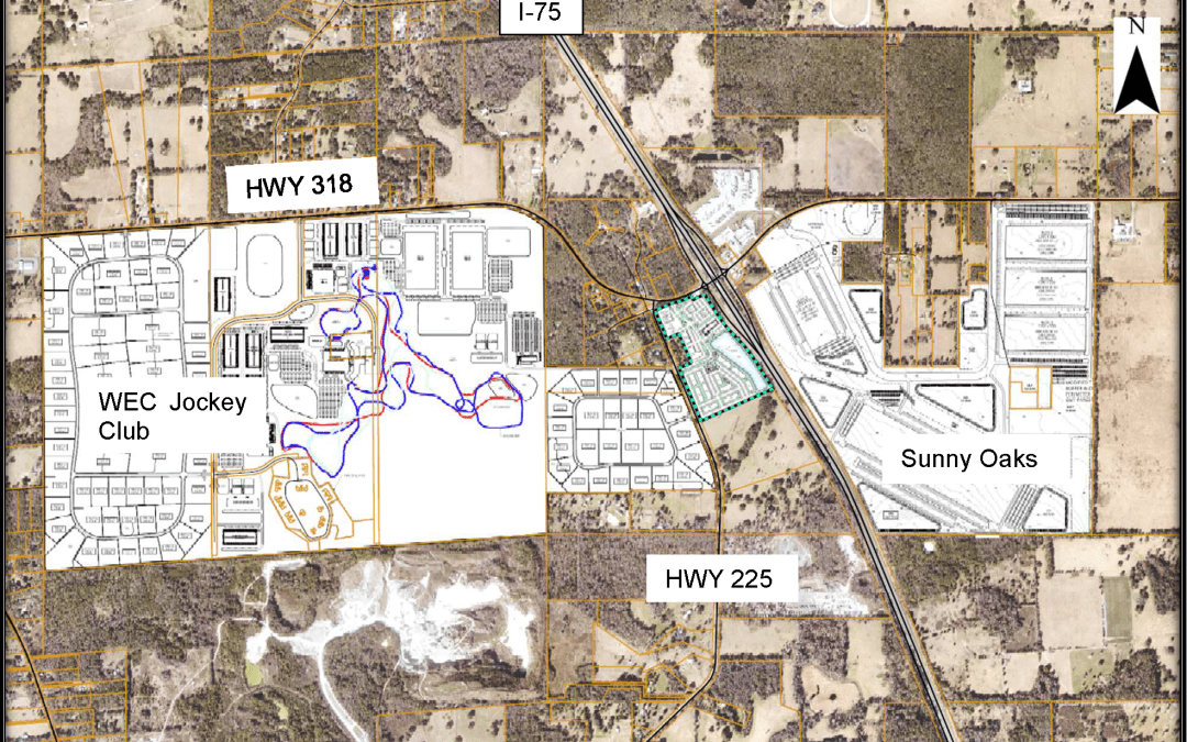
On this map provided by Marion County, you can clearly see the WEC Jockey Club, Sunny Oaks Regional Activity Center and New Times Development.
Over 11 years ago, the Future Land Use and Zoning on approximately 600 acres surrounding the Irvine I-75 exit at CR 318 was changed by the Marion County Commissioners from rural and agricultural to commercial and industrial. These land use changes will forever transform one of the last remaining rural interchanges on I-75 in Marion County.
In addition, on June 21, 2022 the County Commission approved a Planned Unit Development (PUD) on the 1,029-acre former Ocala Jockey Club property to allow for a new equestrian event facility, 100 RV sites, 120,000 square feet of commercial uses and 94 clustered home sites to be built.
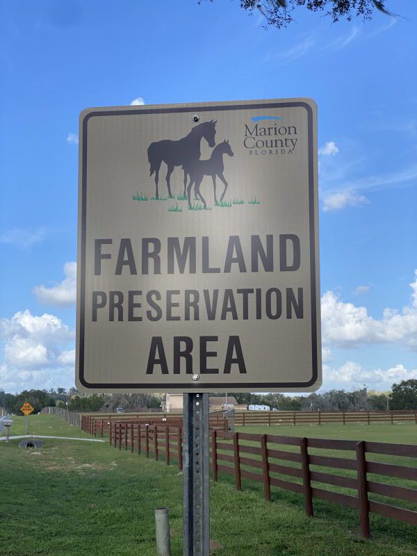
Because Irvine and the former Ocala Jockey Club are located in the Farmland Preservation Area, Horse Farms Forever has kept a close watch on all of the recent land use decisions and activity surrounding the Irvine exit and the proposal by the World Equestrian Center.
The three major developments we are watching are:
- World Equestrian Center–Jockey Club
- Irvine/Sunny Oaks Regional Activity Center
- New Times Development
World Equestrian Center–Jockey Club
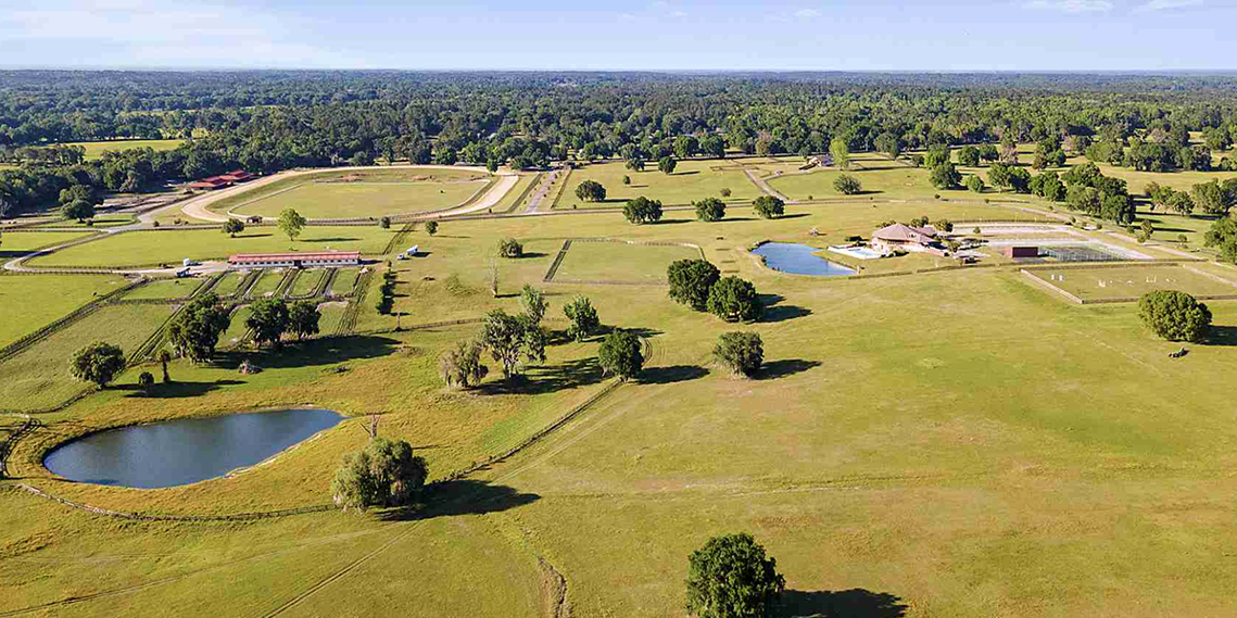
The World Equestrian Center-Jockey Club (WEC-JC) Planned Unit Development (PUD) application to develop the 1,029-acre property into an equestrian facility was approved by the Marion County Commission on June 21, 2022 with several conditions. One of the conditions was to limit the use of the facility to equestrian uses only, as per the approved WEC Rural Land Use designation.
WEC-JC PUD plans included:
- Approximately 520 acres for open space and an equestrian event facility with 9 arenas and grand stands (9,000 seats total), polo fields, and renovation of the existing 4*level cross country course for three-day eventing.
- Approximately 89 acres to construct a new event/clubhouse, a 100 site RV park, and 120,000 square feet of commercial and retail space to support the equestrian events.
- Approximately 420 acres for 94 clustered home sites to allow for large, open common areas for equestrian uses.
- Water and wastewater treatment facility to protect water quality.
Challenged and Settled
After the County Commission voted to approve the PUD application, it was challenged with a Petition for Writ of Certiorari against Marion County and Golden Ocala Equestrian Land, L.L.C., owners of the WEC-JC property, by several neighbors including Damian and Rebecca Guthrie and Don Love, et al. and Save Our Rural Areas, Inc.
The administrative challenge was settled on March 7, 2023 in a Joint Stipulation of Dismissal and the development of WEC-JC will now be able to move forward, as stated in the settlement agreement. The agreement defines the uses of the property that are not permitted (for example, gas stations), and it also clarifies how the property will be buffered, lit, and the requirement for water and waste water management. The settlement also limited the use of WEC-JC to equestrian activities only, with one exception for the use of the fields for amateur youth sporting events. It also recommended further research of sites on the property that may have historical significance.
Learn More About WEC Jockey Club
- Horse Farms Forever’s Position Statement on the WEC JC.
- Full Settlement Agreement from the administrative challenge.
- Ocala Star Banner article from June of 2022 describing the County Approval at that time.

Doug Engle, Ocala Star-Banner
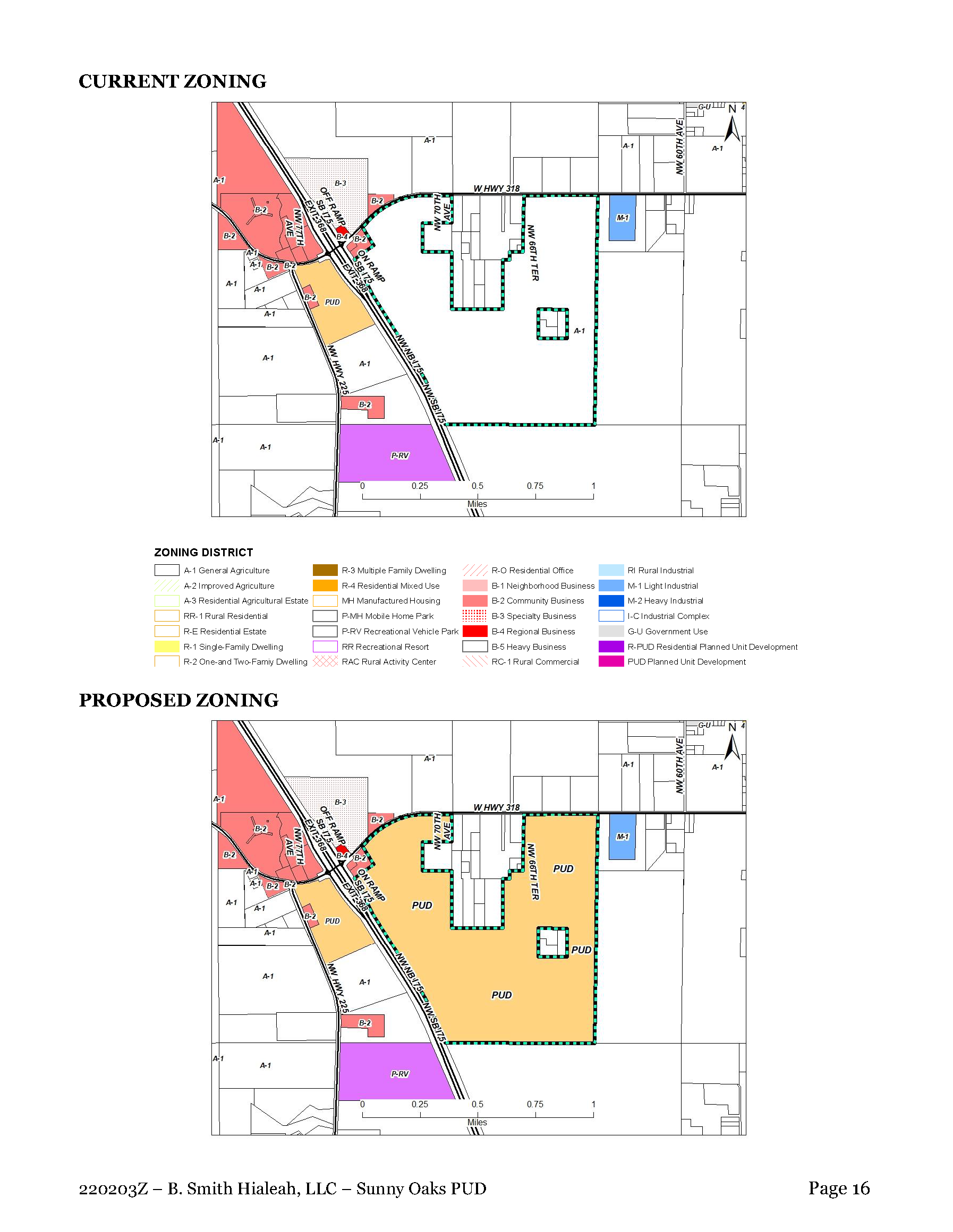
Irvine/Sunny Oaks Regional Activity Center
The Irvine/Sunny Oaks Regional Activity Center (RGAC) encompasses nearly 600 acres of land at all four corners of the Irvine I-75 interchange at CR 318. In 2012 and in 2014 the Future Land Use was changed by the Marion County Commission to Employment Center, Commerce District and a Regional Activity Center, which allows for millions of square feet of commercial and industrial development to be built. While these parcels are located within the Farmland Preservation Area boundaries, these Future Land Use designations overlay and override the Farmland Preservation Area regulations and restrictions.
An application for a Planned Unit Development (PUD) on 453 acres of the Sunny Oaks RGAC was approved on March 1, 2022 by the Marion County Commission. The PUD will include five warehouses totaling 4 million square feet on 427 acres, 28 acres for commercial use, 3 acres for a fire station, and 5 acres for a water treatment plant. The County Commission also required a detailed master plan, with traffic, lighting, and sound studies to be submitted for approval. Once those studies are approved, the PUD can proceed in phases, with road improvements completed for each phase.
However, the Sunny Oaks PUD was challenged with a Petition for Writ of Certiorari on March 31, 2022 filed by over a dozen petitioners and Save Our Rural Areas, Inc. That action has been dormant for over a year.
Horse Farms Forever took a neutral position on the Sunny Oaks PUD because the Future Land Use designations were approved over a decade ago. We provided detail about the project in this blog, published in February of 2022.
Learn More About Sunny Oaks
- Horse Farms Forever’s Position Statement on the Sunny Oaks RGAC
- Growth Services Staff Report about the Sunny Oaks RGAC
- Site Plan for Sunny Oaks PUD
- Marion County’s Comprehensive Plan (Search for Irvine Regional Activity Center)
New Times Development
On the southwest corner of the intersection at I-75 and CR 318 is a 41-acre parcel with an approved Planned Unit Development (PUD) that is valid through 2025. This existing PUD allows two hotels, two restaurants, a convenience store with gas station, and 358,000 square feet of commercial use to be built.
In December, 2022 an application to modify the existing PUD was submitted by New Times Development to the Marion County Commission. The new PUD included 336 apartments on 22.57 acres, one hotel, two restaurants, a gas station and 37,400 square feet of retail.
Due to multiple concerns raised by County Commissioners at the December Commission meeting, the application was withdrawn. However, the existing PUD for this 41-acre parcel remains in place and can be implemented once a traffic study is completed, road improvements are made and potable water/wastewater treatment are addressed.
The existing PUD does not have to comply with the Horse Farms Forever Comprehensive Plan Text Amendment that became effective in April, 2022 because the PUD was approved before the Text Amendment was in place.
For all future applications for Zoning Requests and Special Use Permits in the Sunny Oaks RGAC they must “be consistent with and preserve, protect and support and enhance the rural, equestrian, and farmland character of the Farmland Preservation Area.”
A User-Friendly Guide to Zoning Jargon
Future Land Use (FLU) Designation: a classification of a property that explains what types of development can be built on that property in the future.
Future Land Use Map: The future land use map is a community’s visual guide to future planning. The future land use map should bring together most if not all of the elements of the comprehensive plan such as natural resources, economic development, housing and transportation.
Zoning: A method of urban planning in which a municipality or other tier of government divides land into areas called zones, each of which has a set of regulations for new development that differs from other zones.
What is the Difference Between Future Land Use (FLU) and Zoning?
Future Land Use FLU designations indicateklk0l,mnb bv fb the intended use and development density for a particular area, while zoning districts specifically define allowable uses and contain the design and development guidelines for those intended uses.
Planned Unit Development (PUD): A type of flexible zoning device that redefines the land uses allowed within a stated land area. PUDs consist of site plans that promote the creation of open spaces, mixed-use housing and land uses, environmental preservation and sustainability, and development flexibility.
Overlay Zone: A zoning district which is applied over one or more previously established zoning districts, establishing additional or stricter standards and criteria for covered properties in addition to those of the underlying zoning district.
Regional Activity Center (RGAC) in Marion County’s Comprehensive Plan: The purpose of a RGAC is: “To allow for compact, high intensity, high density multi-use development which may include a mix of the following uses: retail, office, housing, cultural, recreational and entertainment facilities, hospitality facilities (hotels and motels), and industrial uses that serve a regional area.”
Always Watching

We work hard to keep you informed, and to represent our members' interests in preserving our horse farms, farmland and the unique character and culture of Marion County's 193,000 acre Farmland Preservation Area.
Join the herd. Every voice matters.
What About Zoning?
The Zoning regulations are found in the Land Development Code, which is a separate document with specific guidelines to implement the Goals, Objectives, and Policies of the Comprehensive Plan.
Zoning regulates development through land use classifications and specifies the areas in which residential, industrial, recreational or commercial activities may take place. The Land Development Code was adopted through a series of ordinances by the County Commission, which means that the regulations cannot be changed or waived, except by a further vote of the County Commission.